Post by: Teddy on July 17, 2020, 09:39:37 AM
Feb 28, 1959
Mar 18, 2019
Summit 905 →, ← 4th tributary to Lozva, Photo №10, 18.03.2019 2:06 pm, East slope of Kholat Syakhl, tent location №1, view to the East, Prosecutor Kuryakov signature, M.M. Malishev signature
Feb 28, 1959
Mar 18, 2019
Photo №11, 18.03.2019 2:06 pm, East slope of Kholat Syakhl, tent location №1, view to the North, Prosecutor Kuryakov signature, M.M. Malishev signature
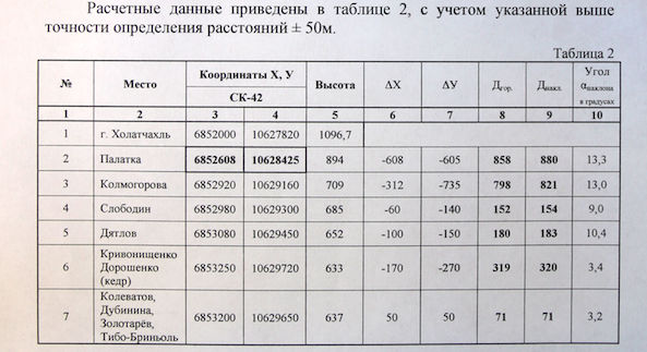
The calculated data are given in the table with accuracy of determining distances ±50 m.
Here is the original document.
| SK-42 X, Y | GPS coordinates | Altitude | ΔX | ΔY | Lenght | Slope | Angle | |||
| Kholat Syakhl | 6852000 | 10627820 | 61.75437 | 59.41858 | 1096.7 | |||||
| Tent | 6852608 | 10628425 | 61.75962 | 59.43045 | 894 | -608 | -605 | 858 | 880 | 13.3 |
| Kolmogorova | 6852920 | 10629160 | 61.76217 | 59.44458 | 709 | -312 | -735 | 798 | 821 | 13.0 |
| Slobodin | 6852980 | 10629300 | 61.76266 | 59.44727 | 685 | -60 | -140 | 152 | 154 | 9.0 |
| Dyatlov | 6853080 | 10629450 | 61.76351 | 59.45018 | 652 | -100 | -150 | 180 | 183 | 10.4 |
| Krivonischneko Doroshenko cedar |
6853250 | 10629720 | 61.76494 | 59.45541 | 633 | -170 | -270 | 319 | 320 | 3.4 |
| Kolevatov Dubinina Zolotaryov Thibeaux-Brignolle |
6853200 | 10629650 | 61.76451 | 59.45405 | 637 | 50 | 50 | 71 | 71 | 3.2 |
Crash course on coordinate conversion from SK-42 to GPS (WGS-84) systems.
You need to know which zone are you in method 1 or and then use the GPS calculator selecting Пулково 1942 10 ГОСТ 51794-2008 [EPSG:28410] from the drop down.
Russians vigorously disagree with the Prosecutor's results. They have been going to the pass year after year and have pinpointed the location of the tent with certainty. On the photos of the prosecutors the pole with the red flag is positioned very close to the cairn and pin left by Russian researcher KAN marked on the map as TENT. Somehow through calculations the prosecutors managed to put it at a distance of 116 m north.

I have updated the information to the Google map with the latest coordinates.
Post by: Teddy on July 17, 2020, 11:29:11 AM
Post by: sarapuk on July 17, 2020, 05:57:26 PM
Post by: Teddy on July 18, 2020, 06:06:21 AM
(https://dyatlovpass.com/resources/340/gallery/Dyatlov-pass-investigation-photo-10.jpg)
(https://dyatlovpass.com/resources/340/gallery/Dyatlov-pass-investigation-photo-11.jpg)
(https://dyatlovpass.com/resources/340/gallery/Dyatlov-pass-tent-location-KAN-1.jpg)
(https://dyatlovpass.com/resources/340/gallery/Dyatlov-pass-tent-location-KAN-2.jpg)
Dyatlov group tent area
Monument to the history of the Urals and UPI
Guarded by conscience
11 km Otorten
Зона палатки группы Дятлова
Памятник истории Урала и УПИ
Охраняется совестью
11 км Отортен
(https://dyatlovpass.com/resources/340/gallery/Dyatlov-pass-tent-location-KAN-3.jpg)
Aвторы поиска 2012-2013
А. Константинов / Чебоксары
Игорь Б. / Екатеринбург
А. Кошкин / УПИ
Search authors 2012-2013
A. Konstantinov / Cheboksary
Igor B. / Ekaterinburg
A. Koshkin / UPI
Post by: MDGross on July 18, 2020, 10:59:26 AM